Sunday 26 March 2017

25th March 2017. G/WB-014 SOTA Activation visit.

G/WB-014 Burrow. 25th March 2017.
Grid SO 381830. Altitude 358M.

Our third and final activation of the day was going to be G/WB-014 Burrow. We arrived at around 11:30 a.m. and parked the car at grid SO 389833 just outside the church. We set off following the Shropshire Way until we came to the field marked with the red circle, this had recently been ploughed and made ready for summer, so I decided to go around the edge of the field as marked by my green route. There is a map/plan on a gate showing that a local land owner has allowed access across their field. They have also installed a bench to allow a rest and enjoy the fantastic views.
This was a fairly easy walk with just a few steep hills but nothing too strenuous, the journey  took us around 45 -50 minutes with a few rest stops for Michelle. On arrival I set up the 2M dipole and also my new homebrew 20M dipole. My first QSO was with G6DFD (Mike) a fellow club member of mine and friend. Followed with a further 8 more QSO's including 3 S2S's with GW4TJC/P (Simon), GW4VPX/P (Allan) and GW7HEM/P (Mike). I tried my new antenna and again a SOTA day with wall to wall contests on 20M (better luck next time I hope).
The centre photo above is the view from the bench, this was a good activation and the sun was now beaming and it was getting very warm for March. On the way off the summit I realised that we could see Brown Clee Hill and Titterstone Clee Hill quite clearly off in the distance.


25th March 2017. G/WB-018 SOTA Activation visit.

G/WB-018 View Edge. 25th March 2017.
Grid SO 422809. Altitude 321M.

Our second activation of the day was going to be G/WB-018 View Edge. This was a very easy walk from where I parked my car at Grid SO 42635 80561. I have read that some people operate from here and others from the other side of the road, I believe they are both in the AZ. On arriving at my activation point I realised there was going to be a small problem as I had dropped part of my 2M dipole on my descent from the last summit. Lesson learnt check your gear when you get back to the car! I managed to hang my dipole in an adjacent tree.


This was the first time that I believed I was not going to qualify this summit, I had my first QSO with 2E0MDJ (Matt) one of my top chasers at 09:53 a.m. and then waited for 27 minutes to finally finish the activation after only 5 QSO's. I think it will be a long time before I return to this summit and I will bring my HF antenna.

After the activation I returned to the previous summit and walked half way back up my descent route to find the missing parts of my 2M dipole, in total adding around 30 minutes to my days travel time.

25th March 2017. G/WB-015 SOTA Activation visit.

G/WB-015 Callow Hill. 25th March 2017.
Grid SO 460850 . Altitude 336M.

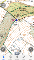
Today's activation's was going to consist of three summits, the first being G/WB-015 Callow Hill. We left home at 07:30 a.m. and headed towards Craven Arms on the B4368 until we approached the cross roads (Greenway Cross) and headed towards Lower Dinchope, we parked the car at
SO 45701 85349 at 08:05 a.m. From here you can see the Tower
 Flounders' Folly our summit location. Today's visit was Michelle (XYL) and myself as Jamie was away in Italy. We started our ascent and I had decided to go straight up, this was too much for Michelle so she turned around half way up and headed back to the car.


As seen from the photo above the ascent was very steep and muddy, I must admit by the time I reached the summit I had a few sweat streaks running down my forehead. (Not a recommended ascent route). The preferred route I think was my descent route. I was happy with my activation on 2M, I did try using my handheld to start with but there seems to be a problem with it so after my first QSO I reverted back to my Yaesu FT 817. My final QSO was with EI9GLB (Jim) this was my second activation with Jim as I spoke with him last week at GW.NW-018, there seemed to be a lift on.

The first photo I took at the summit was myself and the gate (my forehead tells it all). After 25 minutes and 9 QSO's one being a S2S with 2E0LMA (Lee) it was time to pack up and head to my second summit of the day, as I said I had decided that my ascent route was not a good descent route as it was too steep and with the wet ground I didn't want to end up with an injury.


Saturday 18 March 2017

18th March 2017. GW/NW-018 SOTA Activation visit.

GW/NW-018 Moel Llyfnant. 18th March 2017.
Grid SH 808352. Altitude 751M.

Our first visit to Moel Llyfnant which we saw a few weeks ago when we activated the summit next door (Arenig Fawr). The weather was not on our side today as visibility was down to about 30 yards at best. The rain was already coming down as we arrived at around 10.10 a.m. We parked by the gate at Nant Du just off the A4212 (marked with blue circle on map below), we sorted our gear and walked the 1.6 miles down the small track until we reached the disused farm house (marked with the red circle on the map below). From here we followed the track around to the right and headed up the hill. The journey from the farm house to the summit was around 1 hour 10 minutes, the wind was getting very strong and driving the rain horizontally across our path. (we were getting very wet at this point).
We had brought with us 2M Dipole as usual and HF endfed but with the wind and weather being so bad we decided just to activate 2M. We were set up in a few minutes and started to call CQ at around 11.42 a.m. Our first call arrived nearly right away with GW0PLP (Don) followed by a further 6 QSO's and my first 2M FM contact to Ireland, this was helped along with Don informing me that there was an Irish station trying to call me. (A very big thank you Don). After only 20 minutes of operation we had decided to call it a day as Jamie and myself were soaked.
We started out descent at 12.15 p.m. and arrived back at the car at around 13.35 p.m. a lot quicker going down with some idea where we were heading.


Saturday 11 March 2017

11th March 2017. GW/NW-049 SOTA Activation visit.

GW/NW-049 Gyrn Moelfre. 11th March 2017.
Grid SJ 184294. Altitude 523M.

Today's revisit to Gyrn Moelfre after our last activation on New Years eve 2016, We parked at the same spot next to the church yard GD SJ 181303. The main difference on this trip, we both now had two walking poles each, last weeks summit we had one pole each and after reading a few other Sota blogs everyone seamed to agree two poles is better. Well the answer to that is YES it made the ascent easier (this is a hard climb anyway mostly very steep).
We followed the green route, a slightly different route than last time to see if it was any easier, I don't really think it was. As seen on the above photo's most of the ascent is steep. We took 40 minutes to reach the summit then set up camp. As usual Jamie set up the 2M dipole and for this activation I had made a 17M dipole to try, after last weeks attempt of activation on HF and wall to wall contest stations. I had one contact to Greece (it works) but the band was very quiet.

We had 8 QSO's on 2M and 1 on 17M, the weather was not too bad and the wind had not really been a problem, all in all a pleasant morning out. We started our descent at 12:10 p.m. after lots of CQ Sota call's on 18.131 Mhz. Maybe another day might be better. We made it back to the car in 30 minutes and started our journey home.


Sunday 5 March 2017

4th March 2017. GW/NW-011 SOTA Activation visit.

GW/NW-011 Arenig Fawr. 4th March 2017.
Grid SH 827369. Altitude 854m.

This was going to be the hardest summit we have completed so far. We left home at 8:15 a.m. (Telford) and headed towards Wales on the A5, eventually turning onto the A494 sign posted to Bala, then finally on the A212 which took us past Llyn Celyn Reservoir.
Then we turned left down a small road signed Arenig 1 mile (Arenig Fell Race), this took us to grid SH 82271 39259 a small pull in with room for a few cars time 10:25 a.m.


We parked at the blue circle on the above map and made our way up the green route, following rough directions from other Sota blogs. We found it hard going and was glad that we had purchased gaiters and walking poles as we found lots of boggy areas. The gaiters and poles saved us from a good soaking more than once. A very good idea to purchase these, a suggestion from M0JZH (John) a good friend of ours.
 (well done John).
We had many stops on the way up for a breather and the odd drink of water and Kendal mint cake. We thought Cadair Berwyn was hard but we believe this is harder.

We finally arrived at 13:05 p.m. after a good 2 1/2 hours walk up, the last 30 minutes of ascent was covered in cloud and it was lightly snowing, we met a few local walkers at the summit and they suggested an alternative route down which we used. I set up my 2m dipole and mast for HF, everything tested good and I was ready to go. During this time Jamie had been cooking our bacon and black pudding sandwich's. I knew I took him for a good reason lol. Jamie said eat first dad then play on your radio,
(a good idea).
Then I gave out a CQ call and moved off to 145.550 mhz as usual, I had a pile up like I have not had before, 17 qso's in 23 minutes. All I can say is thank you all it was great. I tried HF but the whole band was covered with contests, guys keep away from the QRP sections please.
Our descent had a few little problems (wish we had not listened to others). The first thing we found there was not really any prominent tracks and with the covering of snow made it a little tricky. Eventually we made it to the quarry which had its own lake area, we followed the track we had found and came across a small stream crossing with a ladder across it (as seen above). Yes I agree it was an easier, well not as steep ascent but it turned into 3 times as far to go. So in the end we had a final walking distance of 9.2 miles. (I suggest if you go up to this summit come down the same way).